
Recently added item(s)
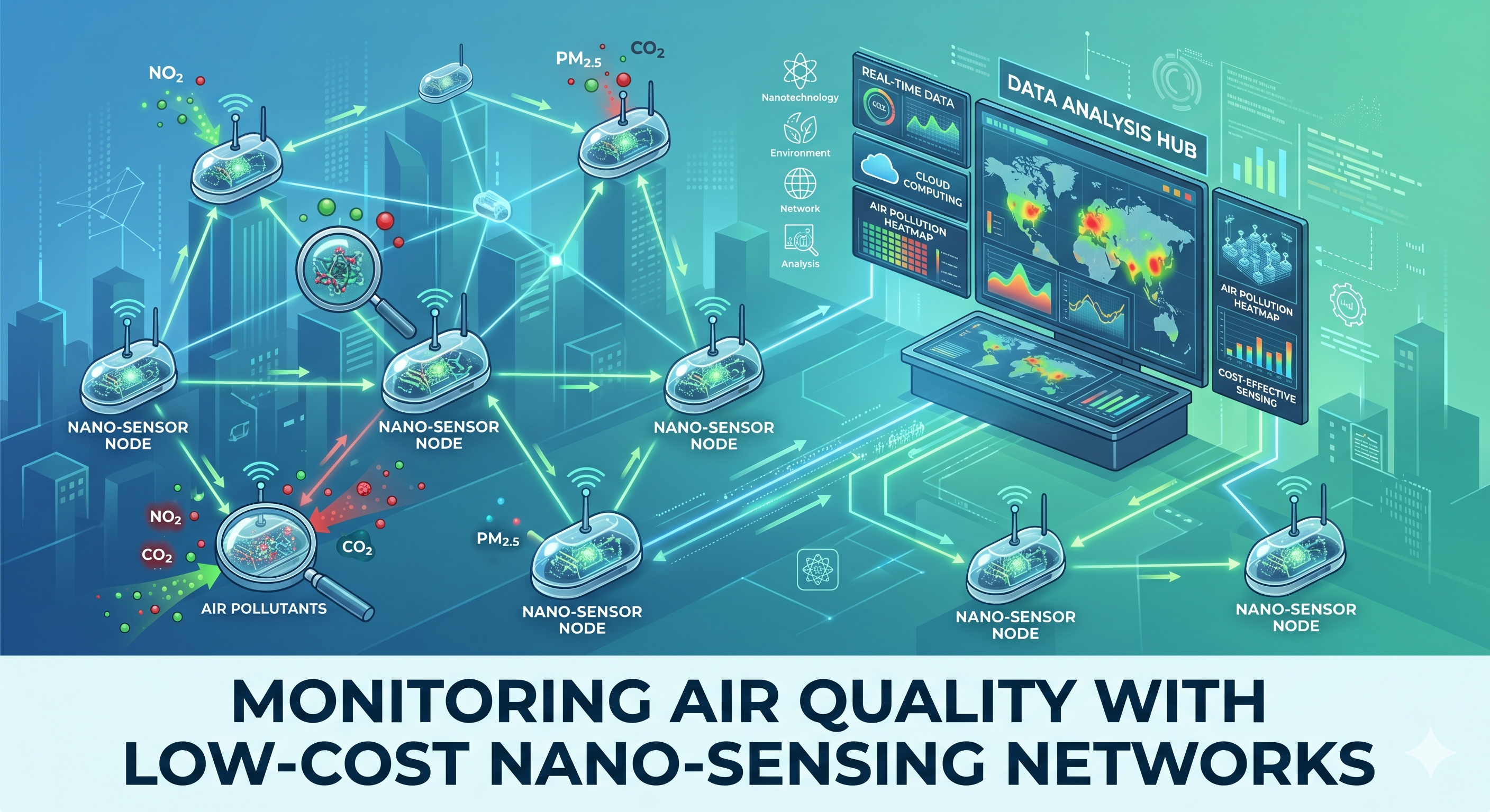
Air pollution is often described as an “invisible killer.” It does not always appear as thick black smoke; sometimes, its deadliest components are microscopic particles or invisible gases that we inhale without a second thought. Despite its subtlety, the World Health Organization estimates that air pollution is responsible for seven million premature deaths annually worldwide. Traditionally, our defense against this threat has been a sparse network of regulatory-grade monitoring stations—bulky, expensive (often exceeding $100,000 each), and requiring skilled operators. These stations provide extremely accurate data, but only for the large region they represent.
Imagine trying to map the intricate temperature variants of a major metropolis using only five thermometers placed kilometers apart. It is impossible. Air pollution is no different; concentrations of traffic-related pollutants can vary significantly from one side of a street to the other, or from ground level to the fifth floor of an apartment complex.
To bridge this crucial information gap, we are witnessing a paradigm shift: the deployment of Low-Cost Nano-Sensing Networks. These systems sacrifice the regulatory precision of a master station in exchange for high density, real-time, hyperlocal data. They represent a new generation of atmospheric surveillance, empowered by nanotechnology.
The Nanotechnology Advantage: Squeezing Labs onto Chips
The defining feature of these low-cost systems is the “nano-sensor.” A sensor typically detects a pollutant through chemical reactions or physical changes occurring on its surface. Nanotechnology enhances this process at the atomic and molecular levels.
Nanomaterials, such as graphene, carbon nanotubes, and metal oxide nanoparticles, possess a staggering surface-area-to-volume ratio. A gram of certain nanomaterials can have a surface area equivalent to several football fields. This massive surface provides an exponentially larger platform for gas molecules to react with, dramatically increasing sensitivity and allowing sensors to be miniaturized down to the millimeter scale.
How Nano-Sensors Work in Low-Cost Units
While reference instruments use complex spectroscopic methods, nano-sensors generally fall into two categories:
-
Electrochemical Sensors: A target gas reacts with a nano-coated electrode, creating an electrical current proportional to the gas concentration.
-
Metal Oxide Semiconductor (MOS) Sensors: The target gas reacts with the surface of a heated metal oxide nanostructure, changing its electrical resistance.
By integrating several of these chips, along with optical particle counters for particulate matter (PM2.5 and PM10), GPS, and cellular or LoRaWAN communication units into a single weather-proof box, scientists can create a powerful monitoring node for a few hundred dollars. When deployed by the dozens or hundreds, they form a “sensing network.”
Frontlines of Current Research (2024-2026): Vertically Mobile Sensing and ML Integration
The field of low-cost air sensing is rapidly evolving, moving beyond stationary poles to dynamically mobile and “smart” systems.
Aerial Vigilance: Drones with Air Sensors
A significant breakthrough published in Nature npj Clean Air in February 2026 demonstrated the feasibility of using custom-built drone platforms to measure air pollution vertically. Research teams performed multiple flights in South Delhi, a densely populated urban environment known for extreme haze events. Measuring haze at altitude has historically been expensive (using aircraft) or lacked resolution (using satellites). Drone-based measurements fill this crucial vertical data gap.
The unique advancement was a customized vertical aerosol sampling inlet designed to minimize particle loss caused by turbulence from the drone’s rotors. In highly humid conditions—common in haze formation—the system used a silica-gel dehumidifier to ensure reliable PM2.5 results. The vertical data suggests that current air quality model simulations significantly underestimate PM2.5 concentrations during haze episodes. These “vertical insights” are critical for understanding how haze forms and mitigates in megacities.
Smart Calibration and Event Forecasting
Another frontier of research is the integration of low-cost IoT sensor data with Machine Learning (ML) and predictive modeling. Because low-cost sensors are susceptible to environmental interferences (temperature and humidity) and sensor drift, AI is being used to develop dynamic calibration models in real-time.
Research published by MDPI recently showed that ensembles of tree-based and gradient-boosting ML algorithms (like Random Forest and XGBoost) can quantify and forecast short-term pollutant peaks in residential indoor air. These ML-driven responses enable smart automated ventilation or real-time alerts, supporting predictive risk management rather than static historical averages.
Clinical and Epidemiological Connections: Bridging Data to Health Outcomes
The ultimate purpose of dense sensing networks is to support public health interventions. Traditional health studies often relied on a single regulatory monitor’s average daily data, missing acute exposure events. Low-cost networks provide “hyperlocal” exposure metrics that are revolutionizing how we study air pollution and disease.
Studies using citizen-gathered data from databases like sensor.community and PurpleAir have used standard Quality Control (QC) frameworks (such as the FILTER framework) to “correct” raw sensor data using nearby reference station data. By integrating thousands of corrected sensor nodes with sparse reference stations, useful data density increased tenfold, allowing epidemiological research to pinpoint specific pollution hotspots linked to asthmatic flare-ups or cardiovascular strain in vulnerable communities. Protocols for systematic reviews are currently under protocol development to determine the relationship between low-cost sensor data and respiratory and cardiovascular health in specific worker populations, particularly those in coastal areas exposed to coastal dust and sea spray interferences.
Advantage–Risk Evaluation: A Complementary Approach
Low-cost nano-sensing networks are not intended to replace regulatory stations; rather, they are highly complementary. Their implementation requires a transparent understanding of their strengths and weaknesses.
Advantages
-
Hyperlocal Spatial Resolution: Regulatory networks provide a sparse map. LCS networks offer a high-definition image, revealing spatial variability and “source apportionment”—identifying which busy road or factory is contributing disproportionately to local pollution.
-
Temporally Dense Data: Most LCS units provide real-time or near-real-time readings, crucial for detecting transient spikes (cooking emissions indoors or traffic jams outdoors).
-
Democratization and Citizen Science: Their affordability enables community groups, schools, and individuals to participate in monitoring their own environments, fostering awareness and advocacy.
-
Gap Filling in Underserved Regions: In low- and middle-income countries, LCS networks may fill large geographical voids lacking any regulatory monitors, providing the first critical baseline data.
Risks and Challenges
-
Data Accuracy and Interferences: The defining weakness. MOS and electrochemical sensors are highly susceptible to changes in ambient temperature and relative humidity. High temperatures can cause non-linear sensor biases, potentially altering sensor sensitivity. This means raw data from low-cost units is unreliable for regulatory enforcement.
-
Cross-Sensitivity: A sensor intended for Ozone (O3) might react to Nitrogen Dioxide (NO2). Advanced multi-pollutant units and complex ML algorithms are required to decouple these overlapping signals.
-
Sensor Drift and Lifespan: Nano-sensing surfaces are sensitive to environmental damage and can “poison” or drift over time, meaning their response changes. They require regular calibration or replacement.
-
Data Integrity and Quality Control: The lack of a standardized QC framework for citizen science can lead to misinformation or panic if faulty sensors are deployed without validation against benchmark instruments.
Conclusion: The Road Ahead to Smart Cities
Monitoring Air Quality with Low-Cost Nano-Sensing Networks has transitioned from a purely academic endeavor to a vital tool in smart city infrastructure. They are our new “sentry” system, providing the necessary spatial granularity to map the dynamic shifts in our atmospheric environment. While we must approach raw LCS data with caution and apply rigorous calibration protocols, their unique ability to fill spatial data gaps makes them indispensable for personal exposure monitoring, educational community science, and developing data-driven policies to combat air pollution. In the near future, the most robust monitoring strategy will be a hybrid one, where sparse, elite reference stations act as anchor points for vast, agile networks of nano-sensors on the ground and in the air, creating a truly comprehensive view of the air we breathe.